Rethinking the Most Valuable Real Estate in Modern Cities
The curb is often treated as a passive strip of asphalt whose primary purpose is storing private vehicles. Yet a typical parking stall occupies public land beside the very destinations that make a neighborhood valuable: shops, homes, schools, transit stops, cafés, and civic spaces. That space can support far more than a stationary car. It can become a shaded seating area, a protected cycle track, a rain garden, a loading bay, or a safer place for people to cross and gather. For residents looking to make everyday trips easier without depending on a car, the curb is one of the most practical places to begin. Even a smarter curbside strategy can change how a block functions.
Growing urban density makes these choices more urgent. Deliveries, buses, ride-hailing, bicycles, accessibility services, outdoor dining, and pedestrians all compete for limited street space, while demand for parking remains politically powerful. The question is not whether cars have a place in cities, but whether storing one private vehicle in the most accessible public location is always the best use of that land. Reallocating selected curb spaces toward active, flexible uses can produce compounding benefits: stronger local commerce, safer movement, cleaner stormwater management, more physical activity, and public places that encourage people to stay rather than simply pass through.
The Anatomy of Curbside Tradeoffs
A single parallel parking stall is commonly estimated at roughly 160 square feet, although its effective footprint grows when access lanes, turning space, and clearance requirements are considered. That is a substantial amount of public ground devoted to storing one vehicle, often for hours at a time. The Kansas City Area Curbside Management Resource and Guide describes the curb as infrastructure serving several competing functions, including mobility, access for people, commercial access, activation, greening, and storage. Treating storage as the default means other needs are accommodated only after parking demand has been satisfied.
| Curb use | Primary public value | Typical design question |
|---|---|---|
| Vehicle storage | Convenient access for some drivers | Is long-term storage necessary at this location? |
| Parklet or seating area | Social space, outdoor dining, neighborhood identity | Can the space remain accessible and publicly useful? |
| Protected bicycle infrastructure | Safer, lower-cost short trips | Can it connect to a wider cycling network? |
| Delivery or passenger loading zone | Efficient access for commerce and essential trips | Can turnover be managed during peak periods? |
| Rain garden or planted buffer | Stormwater control, shade, and pedestrian protection | Can drainage and maintenance be engineered reliably? |
The comparison is not simply between cars and attractive street furniture. A parking stall offers storage for one vehicle, while a parklet can provide seating for several people, support outdoor commerce, and make a storefront more visible. A loading zone can prevent delivery trucks from blocking travel lanes. A protected bicycle lane can move many more people per hour than a row of parked cars, especially on short urban trips. The right choice depends on context, but the central principle is straightforward: curb space should be assigned according to the needs of the block, the time of day, and the people who rely on it.
Local Economic Vitality Beyond the Parking Meter
Parking is often defended as a prerequisite for retail success, yet the customer is not defined by the vehicle used to arrive. People walking, cycling, or taking transit tend to visit commercial districts more frequently, and research on local spending has repeatedly challenged the assumption that drivers are the most valuable customers. A driver may make a larger single purchase, but a nearby resident who walks to a café several times a week can generate more dependable monthly revenue. Customers arriving without cars also avoid the friction of searching for a space, paying for parking, and navigating congested streets.
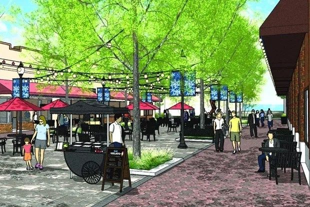
Public-space improvements can reinforce that behavior. Parklets extend the usable frontage of a business, offer customers a place to pause, and create visible activity that signals a lively destination. In streets designed for slower movement, outdoor dining and informal socializing can turn a corridor into a place people choose to visit rather than a route they merely use. The successful transformation of Clematis Street in West Palm Beach, Florida, illustrates this approach. The seven-block corridor operates as a slow, shared street during the week and becomes car-free on weekends through retractable bollards. Individual blocks can be closed, and parking areas can be converted into dining, seating, or vending space in about two minutes.
The Clematis redesign reportedly cost $18.8 million, so it is not a blueprint that every neighborhood can copy immediately. Its value lies in showing how flexibility can preserve automobile access while giving pedestrians and businesses greater priority at the times that matter most. Vehicles travel at approximately 5 to 10 miles per hour in the shared environment, and the corridor has operated for several years without the safety concerns described by critics becoming evident in practice. Smaller communities can pursue the same logic through low-cost pilots, temporary closures, and carefully managed curb allocations.
- Customers who live nearby can visit more often when walking and cycling routes feel safe.
- Outdoor seating increases the visible activity and capacity of cafés and restaurants.
- Loading zones reduce blocked lanes and make deliveries more predictable for small businesses.
- Flexible closures allow streets to support markets, festivals, dining, and ordinary traffic at different times.
- Street trees, seating, and slower vehicle speeds can make a commercial district feel like a destination.
Economic resilience also depends on reducing the cost of access. Not every household can afford a car, and even households that own one may prefer walking, transit, or cycling for short trips. A district that offers several reliable ways to arrive reaches more customers, workers, older adults, young people, and visitors with disabilities. The goal is not to eliminate driving from every commercial street. It is to stop making private vehicle storage the measure of whether a place is accessible.
Green Buffers and Everyday Public Health
Asphalt creates a double problem: it consumes public space and prevents rain from soaking into the ground. Replacing selected paved areas with planted curb extensions, rain gardens, or permeable surfaces can slow and filter runoff before it reaches overloaded drainage systems. The U.S. Environmental Protection Agency examined distributed stormwater controls across 20 watersheds and found that green infrastructure applied to new development and redevelopment could avoid hundreds of millions of dollars in flood losses over time. The analysis also indicated that retrofitting existing areas could produce still greater benefits.
A small rain garden will not solve a regional flood risk by itself, and plantings require proper engineering, irrigation during establishment, and long-term maintenance. However, many small interventions can work as a network. A planted curb extension at one intersection, a permeable parklet on the next block, and street trees near a transit stop collectively reduce runoff, provide shade, and soften an otherwise harsh pedestrian environment. Green buffers also create physical separation between people and moving traffic, which can make walking and cycling feel safer even when the road remains open to vehicles.
The health case extends beyond air quality and crash prevention. Built environments influence whether physical activity is convenient enough to become part of ordinary life. Indiana”s Division of Nutrition and Physical Activity links car-dependent environments with less walking, higher weight, and chronic disease, while promoting Complete Streets that serve pedestrians, cyclists, motorists, and transit users of different ages and abilities. Comfortable seating, shade, safer crossings, and connected paths help turn movement from a special exercise session into an incidental part of daily travel.
- Rain gardens and permeable surfaces can capture localized runoff and reduce pressure on drainage systems.
- Raised or planted buffers help separate pedestrians and cyclists from moving traffic.
- Shade and seating make transit stops and walking routes more usable during hot weather.
- Shorter crossings reduce exposure time for children, older adults, and people with mobility limitations.
- More inviting streets can support routine walking, social contact, and lower everyday stress.
Good design must remain inclusive. A parklet should not narrow an accessible path, block a wheelchair ramp, or create confusing obstacles for people with visual impairments. Green infrastructure should preserve drainage access and avoid turning maintenance into an afterthought. Public health improvements are strongest when they combine protection, comfort, and universal access rather than treating greenery as decoration.
A Tactical Playbook for Reclaiming Neighborhood Blocks
The most durable projects usually begin with a focused question: what does this block need at different times of day? A corridor may need loading space in the morning, seating at lunchtime, and a car-free event area on weekends. A neighborhood coalition can gather observations, photograph recurring conflicts, survey merchants and residents, and identify one or two parking stalls suitable for a temporary experiment. Tactical urbanism works because it allows communities to test a change before committing to expensive reconstruction.
- Build a local coalition. Bring merchant associations, residents, disability advocates, transit users, cyclists, property owners, and nearby institutions into the conversation. Agreement on a specific pilot is more useful than general support for better streets.
- Check the municipal rules. Parklet programs often specify speed limits, street classifications, slope, drainage, accessibility, insurance, construction standards, and public access. San Leandro”s guidelines, for example, limit eligible sites to suitable city streets and require applications, design documentation, maintenance commitments, and liability coverage.
- Define the public purpose. Decide whether the pilot is intended to provide seating, greenery, bicycle parking, dining capacity, traffic calming, or a combination. Publicly accessible designs build trust, while commercial uses may require additional approvals.
- Start with a reversible installation. Use modular platforms, planters, removable bollards, paint, signs, and temporary barriers where permitted. Establish a clear trial period and document conditions before and after installation.
- Measure and adjust. Track pedestrian activity, business feedback, loading conflicts, accessibility, maintenance, vehicle speeds, and public use. Keep what works, redesign what does not, and expand only when the evidence supports it.
Maintenance deserves as much attention as construction. A successful parklet needs an identified steward, regular cleaning, healthy plants, safe surfaces, and a plan for snow, storms, vandalism, and emergency access. Municipal guidelines may require application fees, deposits, professional drawings, insurance, and restoration guarantees. Those requirements can appear burdensome, but they clarify responsibility and protect the public right of way. Cities can make participation easier by offering standard designs, technical assistance, small grants, and transparent review timelines.
Pilots should also be evaluated fairly. Counting only removed parking spaces ignores the benefits of increased foot traffic, safer crossings, reduced double parking, and better use of public space. Conversely, enthusiasm should not hide real problems such as blocked deliveries, inaccessible routes, or displacement of essential loading. A credible trial publishes its criteria in advance and invites feedback from people who use the street in different ways. That process turns curb management into practical civic problem-solving rather than a permanent battle between parking and pedestrians.
Building People-First Streets One Stall at a Time
Curbside management is not an unchangeable urban fact. It is an ongoing democratic choice about how limited public land should serve mobility, commerce, safety, nature, and community life. Parking remains important for some residents, workers, visitors, and people with disabilities, but it should compete openly with other needs instead of receiving an automatic priority. A well-managed curb can provide access without requiring every trip to begin and end with a privately owned car.
Converting one stall will not transform an entire transportation system, yet small changes can alter expectations. A protected route makes the next bicycle trip more realistic. A shaded seat makes waiting for transit less burdensome. A rain garden makes resilience visible. A lively parklet reminds residents that streets are places for shared life as well as movement. With careful design, transparent measurement, and local participation, cities can trade a little asphalt storage for safer access, stronger businesses, healthier routines, and neighborhoods that invite people to arrive, connect, and stay.